Power from the sun (and gun): Bandar Dataran Solar
March 18th, 2011 | by Sean |A couple of days ago when I wrote about how I thought Malaysia should generate electricity from the sun, I realised that the picture that I carry in my head might not be the same as a reader might form in their own. Worse, I dashed off an image of how I think a ‘residential area solar roof’ should work using the GIMP and a few images I found scattered around the Web, and produced something awful!
Ideas like this pretty much live or die depending on whether people can see for themselves what it will look like, so I tried asking at a popular local forum if there was anybody who liked the idea and might be willing to do an “artist’s impression”. I got a couple of suggestions to use Google Sketchup, which I didn’t know about, and will try. Someone was sure the whole solar roof thing is a non-starter – that’s okay, I’ll add their concerns into the mix soon. A few other replies were ‘No money no talk!”, which seems to be a popular local affliction – the same one that is going to get everyone nuclear power here, because that’s where the biggest profits / commissions / kickbacks / facilitation fees are.
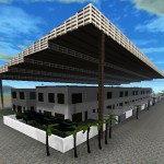
All I had installed last night and ready to go, that I knew could draw 3D with, was Sauerbraten. I’d never tried editing a map in Sauerbraten before, but it’s actually a masterpiece of simplicity. OK, I know nothing about 3D design or art and it’s obvious to me that the finished article still looks like a cheap video game, but it got me started, and quickly too.
What impresses me most about using Sauerbraten to produce this model is just how fast and pain-free creating such a model with Sauerbraten is. Sauerbraten is heavily optimised to do a few things only but do them very well, and that carries over into map-editing. On the down side – and perhaps an experienced Sauerbraten modeller would know how to work around this – is that everything must be arranged around cuboids and simple fractions of cuboids. The roof ended up being much more ‘clunky’ than the image of it that I have in my mind because my 6 hours of Sauerbraten modelling experience just didn’t reveal to me the ‘way of the very large, slim, gently-sloping plane’. It’s good enough to show most of what I mean.
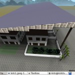
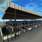
So what does the image show? Well, despite not having any (that I could find) mapping of model dimensions to real world dimensions, it does show the scale of construction I’m talking about: pairs (facing in opposite directions, like in the development I live in) of link-housing units under a single roof. The roof is separate from the houses below.
One thing I did in this model which is different from my original suggestion is to extend the roof past the ‘front yard wall’ of the house. I did this in the model just to make it easier to put the supports in for the roof. My original idea was that the solar roof would extend only a few metres past the front wall of the house. That’s important so that there’s enough sun falling on at least some of the plot for laundry and growing plants. Without some fairly hard-core light modelling, it would be difficult to say how far out the roof can come. The further out the roof comes, the darker it will be beneath it, but the more electrical power can be produced from the same residential area.
The solar roof slopes, the house roofs do not. Malaysia is slightly north of the equator, so a fixed installation of solar panels will point slightly south. Because the link-housing installation depicted here is very large, I think the houses would have to run West-East so that the tilt can be from the fronts of one row to the fronts of the houses behind – or otherwise the difference in heights from one edge of the giant roof to the other may be exceptionally* great.
I imagine the solar roof would be a complete roof. When it’s built, it should be rain-proof, perhaps constructed with corrugated panels over a beam lattice. The solar panels would sit directly on top of this roof. If the roof were not waterproof, there would be a problem with mini-waterfalls dropping metres onto the houses / ground below, possibly causing damage. Another hazard is dropped tools during maintenance – a solid roof (without the solar panels) avoids all that. Having a complete roof might slightly reduce the cost of building the houses beneath (can build in slightly wet weather), and also allows the houses below to be built with flat roofs constructed from cheap materials. If these materials allow heat to escape easily from the house, so much the better.
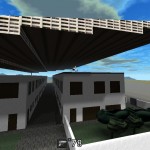
The back alley of such a development would be a dark place, but if my experience of link-housing back-alleys is anything to go by, it’s a dead space anyway. I think it would make sense to include some night-time lighting on the underside of the solar roof (or possibly installed along the roofline of the houses beneath), so that the back alley could be well-lit at night. If it’s lit from down-lights on the bottom of the solar roof, the light should intrude less into bedrooms at night than lights mounted on poles in the road.
In case you want to look at the map yourself, here’s a zip file with the Sauerbraten map inside it. Just unzip it in your [sauerbraten_directory]/packages/base/ and you should either be able to select it in a menu or load it with “/map bds”. If you load it in DMSP mode (Death Match Single Player), you can even shoot a few monsters – there’s some ammo in the longkang (not in real life). Any resemblance between the monsters and my neighbours is entirely unintentional. Also, the name is a play on the name of my residential area ‘Bandar Dataran Segar’. I’m absolutely not suggesting that everyone in BDS cut their roofs off and buy shares in solar – this idea would almost certainly only work well if a residential area was designed this way from the beginning.
bds.zip (Bandar Dataran Solar)
* Using a large example from my earlier post, the big solar roof is 180mx50m. Kuala Lumpur is about the same latitude as Bandar Dataran Solar – 3°N. The sun averages 0°N, so rough calc puts the roof slope at 3°S. Height difference (Opposite) of a roof at 3° incline, for a span (Hypotenuse) of 50m is 50m * sin(3°) = 2.6m. For the 180m span (the row of buildings runs North-South), the height difference would be 9.4m – that’s a long extra (it’s 2m+ at the small end, remember) gap between the top of the building and the bottom of the solar roof.


1 Trackback(s)